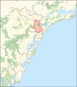
| Wallsend New South Wales—Legislative Assembly | |||||||||||||||
|---|---|---|---|---|---|---|---|---|---|---|---|---|---|---|---|
Interactive map of district boundaries from the 2023 state election | |||||||||||||||
| State | New South Wales | ||||||||||||||
| Dates current | 1894–1904 1917–1920 1927–1930 1968–present | ||||||||||||||
| MP | Sonia Hornery | ||||||||||||||
| Party | Labor | ||||||||||||||
| Namesake | Wallsend | ||||||||||||||
| Electors | 59,050 (2019) | ||||||||||||||
| Area | 116.83 km2 (45.1 sq mi) | ||||||||||||||
| Demographic | Provincial | ||||||||||||||
| |||||||||||||||
Wallsend is an electoral district of New South Wales. It was created in 1894, abolished in 1904, recreated in 1917, reabolished in 1930, recreated again in 1927, reabolished again in 1930 and recreated for a fourth time in 1968.
Originally a blue-collar electorate, Wallsend has always been held by Labor.
Wallsend is in western Newcastle.


